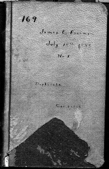
Here are the complete surveyors’ notes from both the 1848 and 1852 land surveys – with typed translations so they’re easier to read. The earliest surveys done in this area were by the federal General Land Office, and they drew the maps and established the grid of township, range and section lines. The grid consists of six-mile square townships, each divided into 36 one-mile square sections. The information about these early surveys is now online, and is available through the Board of Commissioners of Public Lands through the University of Wisconsin library system. Information about the system of measuring that was used, and what the terms mean, is available at this link.
I’ve included all pages that include any of the boundaries of our section. Only one township line in the 1848 survey, and two section lines in the 1852 survey are actually on our land, but the information from the nearby lines gives a sense of what the land was like. (I’ve highlighted the places that are actually on or at the edges of our land – in pink.) The typed ‘translations’ are below each page.
1848 Township and Range line survey
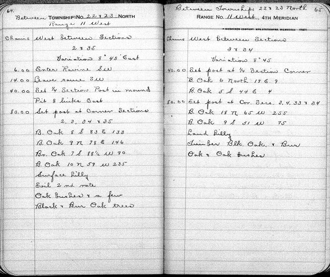
Between Township 22 & 23 North, Range 11 West
Chains West Between Sections 2 & 35
Variation 8 45′ East
6.00 Enter ravine SW
14.00 Leave same SW
40.00 Set 1/4 Section Post in mound pit 8 links East
80.00 Set post at Corner Section 2, 3, 34, & 35
B. Oak 8 S 83 E 133
B. Oak 9 N 78 E 146
Br. Oak 7 S 88 1/2 W 235
B. Oak 10 N 59 W 235
Surface hilly
Soil 2nd rate
Oak bushes & a few Black and Burr Oak trees
Between Townships 22 & 23 North, Range 11 West
Chains West between Sections 3 & 34
Variation 8 45
40.00 Set post at 1/4 Section Corner
B. Oak 6 North 19 E 9
B. Oak 5 S 44 E 4
80.00 Set post at Cor. Secs. 3, 4, 33, & 34
B. Oak 18 N 65 W 255
B. Oak 9 S 51 W 75
Land hilly
Timber Blk Oak & Bur Oak & Oak bushes
Affidavit and surveyor information for the 1848 survey.
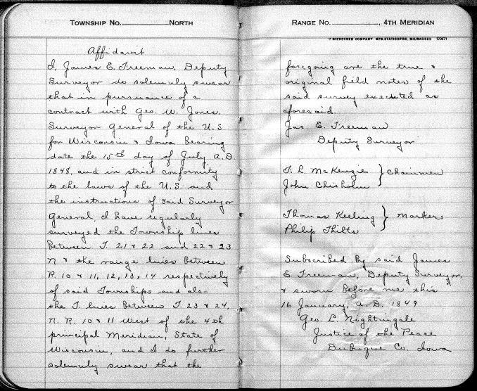
Affidavit
I, James E Freeman, Deputy Surveyor do solemnly swear that in pursuance of a contract with Geo. W. Jones, Surveyor General of the U.S. for Wisconsin and Iowa bearing date the 15th day of July A.D. 1848, and in strict conformity to the laws of the U.S. and the instructions of said Surveyor General, I have regularly surveyed the Township lines between T 21 & 22 and 22 & 23 N & the range lines between R. 10 & 11, 12, 13, 14 respectively of said Township and also the T. lines between T. 23 & 24, N. R. 10 & 11 West of the 4th principal Meridian, State of Wisconsin, and I do further solemnly swear that the foregoing are the true & original field notes of the said survey executed as aforesaid.
Jas. E. Freeman Deputy Surveyor
T.L. McKenzie
John Chisholm Chairmen
Thomas Keeling
Philip Thilts Markers
Subscribed by said James E Freeman, Deputy Surveyor & sworn before me this 16 January, A.D. 1849
Geo. L. Nightingale
Justice of the Peace
Dubuque Co. Iowa
1852 Section lines survey
Township 22 North – Range 11 West
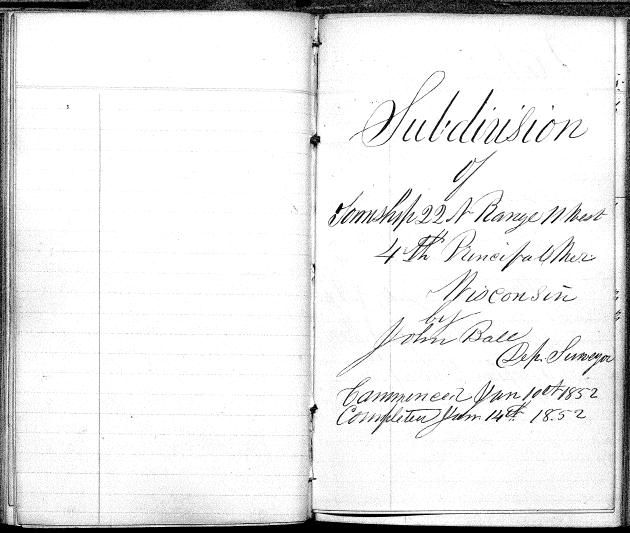
Subdivision of Township 22 N Range 11 West 4th Principal Mer. Wisconsin
By John Ball Dep. Surveyor
Commenced Jan 10th 1852 Completed Jan 14th 1852
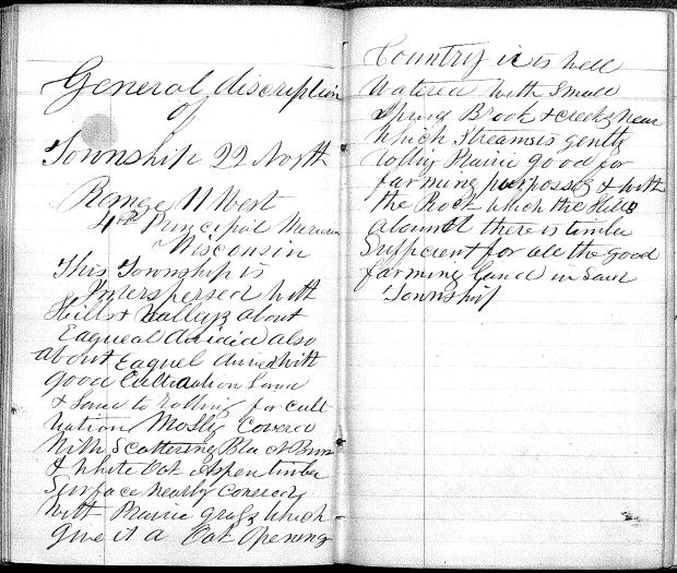
General description of Township 22 North Range 11 West 4th Principal Meridian Wisconsin
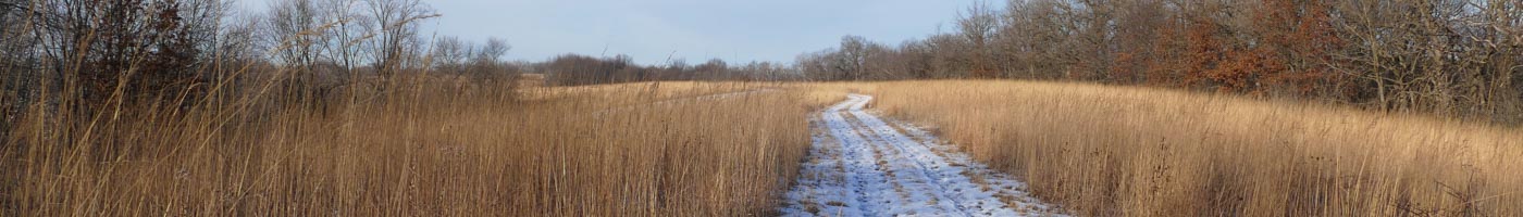
This township is interspersed with hills & valleys about equal divided also about equal divided with good cultivation land and land too rolling for cultivation. Mostly covered with scattering Black, Burr and White Oak, Aspen timber. Surface nearly covered with prairie grass which give it a oak opening. Country is well watered with small spring brook and creeks, near which streams is gently rolling prairie good for farming purposes and with the rock which the hills abound. There is timber sufficient for all the good farming land in said township.
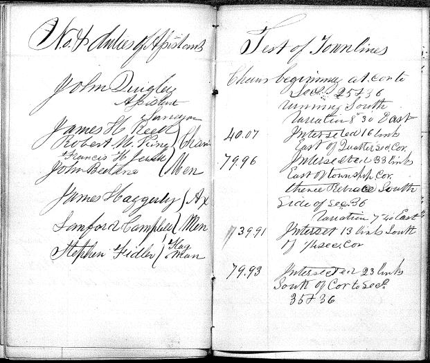
No. & duties of Assistants
John Quigley Assistant Surveyor
James H Reed
Robert M King Chain Men
Francis H Jewell
John D Beeten
James Haggerty
Sanford Campbell Ax Men
Stephen Fidler Flagg Man
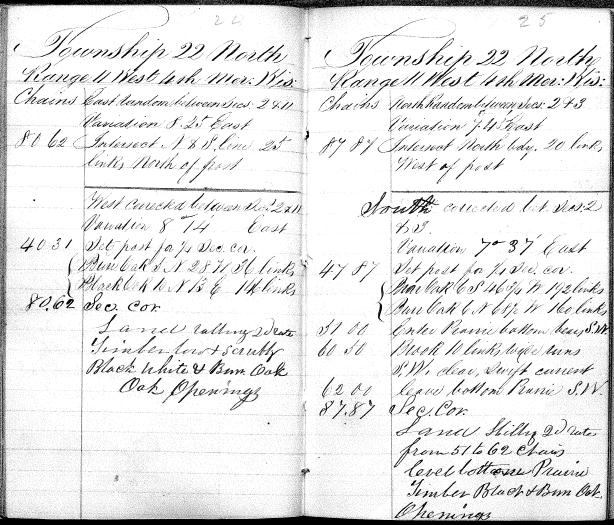
East Random between Secs: 2 & 11 Variation 8 25 East
80.62 Intersect N & S line 25 links North of post
West corrected between Secs: 2 & 11 Variation 8 14′ East
40.31 Set post for 1/4 sec. Cor.
Burr Oak 5 N28 W36 links
Black Oak 10 N13 E146 links
80.62 Sec. Cor.
Land rolling 2nd rate
Timber low & scrubby
Black, White & Burr Oak
Oak Openings
North Random between Secs: 2 & 3 Variation 7 43′ East
84.84 Intersect North bdy. 20 links West of post
South corrected bet. Secs: 2 & 3 Variation 7 37′ East
47.87 Set post for 1/4 sec. cor.
Burr Oak 6 S46 3/4 W192 links
Burr Oak 6 N68 1/2 W160 links
51.00 Enter Prairie bottom bears SW
60.50 Brook 10 links side runs S.W. clear, swift current
62.00 leave bottom Prairie S.W.
87.87 Sec. Cor.
Land hilly 2nd rate from 51 to 62 chains
Level bottom prairie
Timber Black & Burr Oak Openings
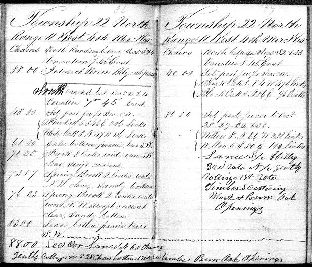
North Random between Sec: 3 & 4 variation 7 45 East
88.00 Intersect North Bdy at post
South corrected bet. Secs: 3 & 4 variation 7 45 East
48.00 set post for 1/4 sec. cor.
Burr Oak 5 S46 E206 links
White Oak 8 N47 W116 links
61.00 Enter bottom prairie bear SW
71.25 Brook 8 links wide runs SW clear, swift current
73.87 Spring Brook 2 links wide NW clear, sandy bottom
76.33 Spring brook 2 links wide runs NW swift current, clear, sandy bottom
83.00 Leave bottom prairie bears SW
88.00 Sec. cor. Land N 60 chains gently rolling
S 28 chains bottom
Timber Burr Oak Openings
North between Secs: 32 & 33 variation 8 45′ East
40.00 Set post for 1/4 sec. cor.
Black Oak 8 N4 W475 links
Black Oak 5 N86 E95 links
80.00 Set post for cor. to sec: 28, 29, 32, & 33
Willow 8 N66 W288 links
Willow 5 S80 E100 links
Land S 1/2 hilly 3rd rate
N 1/2 gently rolling 1st rate
Timber scattering Black & Burr Oak openings
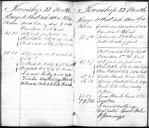
North between Secs: 9 & 10 Variation 8 50′ east
40.00 Set post for 1/4 sec. cor.
White Oak 10 N64 E 49 links
Black Oak 12 N61 1/2 W84 links
80.00 Set post for cor. to Secs: 3, 4, 9 & 10
White Birch 10 N51 1/2 E55 links
Black Oak 10 S27 E 68 links
Land hill 3rd rate
Timber scattering Black & Burr Oak, and White Birch
East Random between Secs: 3 & 10 Variation 8 15 East
79.74 Intersect N & S line 35 links South of post
West corrected bet sec. 3 & 10 Variation 8 30′ East
39.87 Set post for 1/4 sec. cor.
Burr Oak 8 N60 W144 links
Burr Oak 10 S15 E204 links
55.00 Enter Marsh bears NW
56.50 Spring Brook 10 links wide runs N.W. clear, sandy bottom.
68.00 leave Marsh bears N.W.
79.74 sec. cor.
Land rolling 3rd rate
Burr oak openings
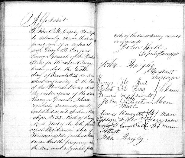
Affidavit
I, John Ball, (Deputy Surveyor) do solemnly swear that in pursuance of a contract with George B. Sargent, Surveyor General of the United States for Wisconsin and Iowa bearing date the tenth day of December 1851, and in strict conformity to the laws of the United States, and the instructions of the said Surveyor General, I have regularly surveyed, and subdivided into Sections, Township No 22, North of Range No 11 West of the 4th Principal Meridian in State of Wisconsin. I do further solemnly swear that the foregoing are the true and original field notes of the said survey executed as aforesaid.
John Ball Deputy Surveyor
John Quigley Assistant Surveyor
James H Reed
Robert M King Chain Men
Francis H Jewett
John D Beeten
James Haggerty Ax Man
Stephen Fidler Flagg Man
Sanford Campbell Ax Man
Attest.
John Quigley
Township 23 North – Range 11 West
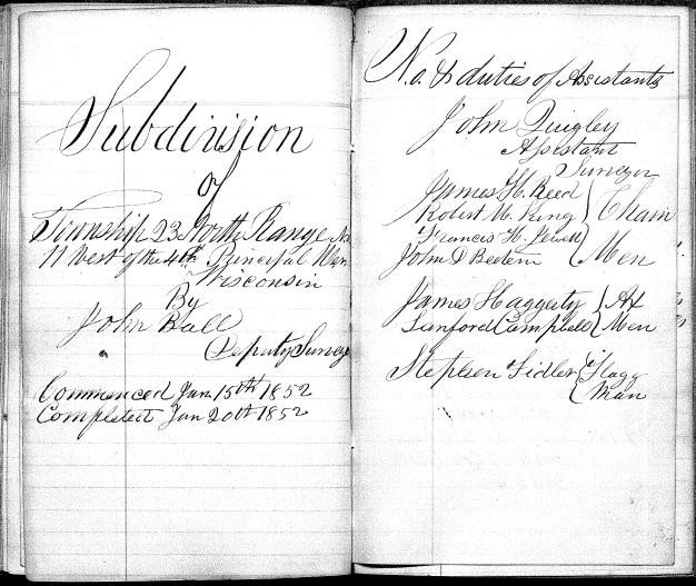
Subdivision of Township 23 North Range 11 West of the 4th Principal Meridian Wisconsin
By John Ball Deputy Surveyor
Commence Jan 15th 1852 Completed Jan 20th 1852
No. & duties of Assistants
John Quigley Assistant Surveyor
James H Reed
Robert M King Chain Men
Francis H Jewell
John D Beeten
James Haggerty
Sanford Campbell Ax Men
Stephen Fidler Flagg Man
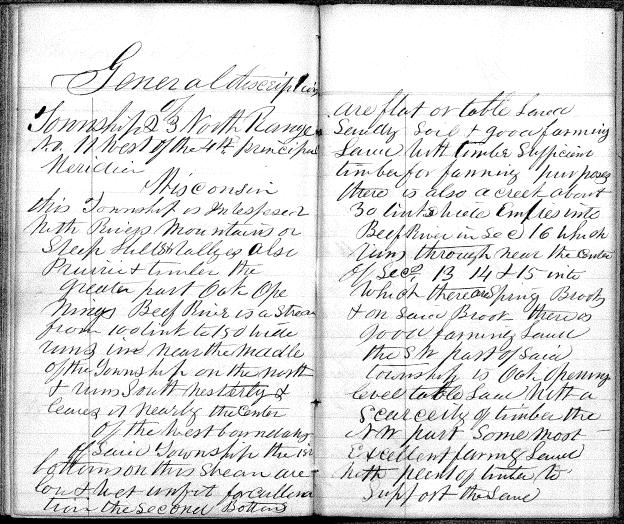
General description
Township 23 North Range No. 11 West of the 4th principal Meridian
Wisconsin
This township is interspersed with rivers mountains or steep hills & valleys also prairie & timber the greater part oak openings. Buff river is a stream from 100 links to 150 links wide runs in near the middle of the township on the north & runs south westerly & leaves it nearly the center of the west boundary. Of said township the 1st bottoms on this stream are low & wet unfit for cultivation the second bottoms are flat or table land sandy soil & good farming land with timber sufficient for farming purposes. There is also a creek about 30 links which empties into Buff River in sec. 16 which runs through near the center of secs. 13 14 & 15 into which there are Spring Brooks & on said brook there is good farming land. The SW part of said township is Oak openings level table land with a scarcity of timber. The NW part some most excellent farming land with plenty of timber to support the same.
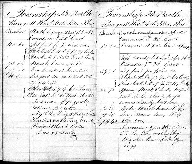
Chains North between secs 34 & 35 Variation 8 20′ East
40.00 Set post for 1/4 sec. cor.
Burr Oak 8 N39 W98 links
Burr Oak 8 N52 E112 links
73.00 Marsh bears NW
77.00 Leave same marsh bears NW
80.00 Set post for cor. to secs 26 27 34 & 35
Black Oak N9 E15 links
Burr Oak 6 N85 West 160 links
Land S 1/2 gently rolling 2nd rate
N 1/2 rolling & hilly 3rd rate
Timber Scattering Burr & Black Oak Low & scrubby
Chains East Random between secs: 26 & 35 Variation 8 20′ East
79.42 Intersect N & S line at post
West corrected bet. Secs 26 & 35 Variation 8 20′ East
39.71 set post for 1/4 sec. cor.
White Oak 8 S79 3/4 W64 links
White Oak 8 N19 3/4 W187 links
65.70 Spring Brook 3 links wide runs NE clear, swift current sandy bottom
73.50 Enter Marsh bears NE
78.50 Leave same bears NE
79.42 sec. cor.
Land gently 2nd rate timber low & scrubby
Black & Burr Oak openings
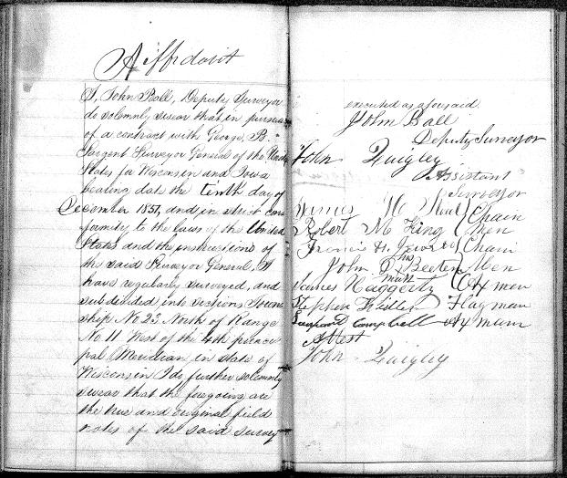
Affidavit
I, John Ball, Deputy Surveyor do solemnly swear that in pursuance of a contract with George B. Sargent, Surveyor General of the United States for Wisconsin and Iowa bearing date the tenth day of December 1851, and in strict conformity to the laws of the United States and the instructions of the said Surveyor General, I have regularly surveyed and subdivided into sections township no. 23 North of Range No. 11 West of the 4th principal Meridian in State of Wisconsin I do further solemnly swear that the foregoing are the true and original field notes of the said survey executed as aforesaid.
John Ball Deputy Surveyor
John Quigley Assistant Surveyor
John Ball Deputy Surveyor
John Quigley Assistant Surveyor
James H Reed
Robert M King Chain Men
Francis H Jewett
John D Beeten
James Haggerty Ax Man
Stephen Fidler Flagg Man
Sanford Campbell Ax Man
Attest.
John Quigley